You’ve probably seen the postcard. That one with the single, lonely cypress tree sitting on a golden hill under a sun that looks like it’s been filtered through an Aperol Spritz. People see that and think, "Okay, that's Tuscany. I’ll just drive there." Then they open a map of Tuscany region Italy and realize the place is actually massive. It’s almost 9,000 square miles of territory. To put that in perspective, you could fit about three Delawares in there with room to spare.
Honestly, the biggest mistake people make is treating Tuscany like a single destination. It’s not. It’s a collection of ten distinct provinces, each with its own personality, dialect, and—most importantly—its own "correct" way to cook wild boar. If you try to see "Tuscany" in three days, you’re basically just going to see the inside of a Fiat rental car.
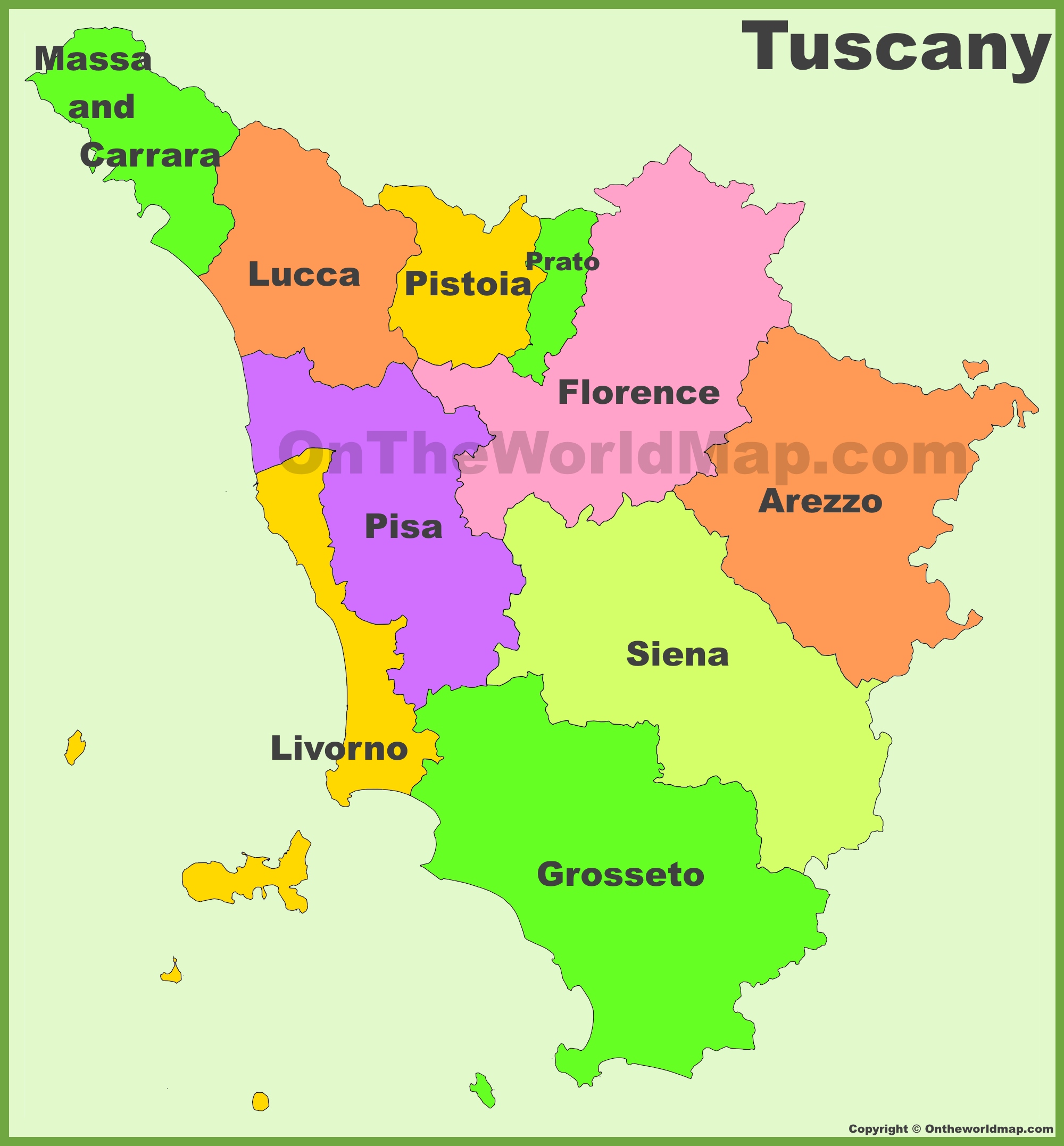
Getting Your Bearings: The Provinces on the Map
When you look at a map, Tuscany looks roughly like a triangle. It’s tucked into the "shin" of the Italian boot. To the north and east, you’ve got the rugged Apennine Mountains acting as a wall between you and Emilia-Romagna. To the west, the Ligurian and Tyrrhenian seas offer a coastline that most people completely ignore because they’re too busy looking for vineyards.
Tuscany is split into ten provinces. Think of them as mini-states:
- Florence (Firenze): The heavyweight. It’s dead center in the north.
- Siena: South of Florence. This is where those "classic" rolling hills live.
- Pisa: To the west, hugging the coast.
- Lucca: North of Pisa, famous for its intact Renaissance walls.
- Arezzo: The eastern frontier, bordering Umbria.
- Grosseto: The wild south, known as the Maremma.
- Livorno: The gritty, cool port city and the gateway to the islands.
- Pistoia & Prato: The industrial and nursery-garden heartland just north of Florence.
- Massa-Carrara: The far northwest, where the marble mountains (Apuan Alps) look like they're covered in snow even in July.
The North: Mountains and Marble
Most people think Tuscany is just hills. They’re wrong. About 25% of the region is actually mountainous. If you head to the very top of the map of Tuscany region Italy, you hit the Garfagnana and the Apuan Alps. This isn't the land of Chianti; it’s the land of chestnuts, farro, and peaks reaching over 6,500 feet.
In the province of Massa-Carrara, the mountains are literally being eaten away. This is where Michelangelo got his marble. If you drive up into the quarries, you'll see trucks carrying blocks of white stone the size of small houses. It’s a moonscape. It’s brutal and beautiful, and it feels nothing like the Renaissance galleries of Florence.
The Heart: Florence and the Chianti Myth
Right in the middle of the map sits Florence. It’s the hub. Most of the trains lead here, and most of the traffic jams start here. If you follow the "Chiantigiana" (the SR222 road) south from Florence toward Siena, you’re in the Chianti Classico zone.
Here’s a tip: "Chianti" is a huge area, but "Chianti Classico" is the specific heartland. You can tell you're in the right spot on the map if you see the "Gallo Nero" (Black Rooster) logo on the wine signs. The geography here is dense. It’s all olive groves and vineyards stitched together like a quilt. It’s gorgeous, but it’s also a labyrinth of hairpin turns. You’ve been warned: 20 miles in Chianti takes an hour. Easily.
The South: Val d’Orcia and the Wild Maremma
If you keep heading south on the map, past Siena, the landscape changes. The trees disappear. The hills become more dramatic, almost naked. This is the Val d’Orcia. It’s a UNESCO World Heritage site for a reason—it’s the exact landscape that Sienese painters used as a backdrop in the 14th century.
- Pienza: The "ideal city" of the Renaissance.
- Montalcino: The fortress town where they make Brunello.
- Bagno Vignoni: A village where the main square is literally a giant steaming pool of thermal water.
Further south still is Grosseto and the Maremma. Historically, this was a swampy marshland avoided by everyone. Today, it’s Tuscany’s "Wild West." You’ll see the Butteri (Tuscan cowboys) herding long-horned cattle. It’s flat near the coast but rises into the Metalliferous Hills and the volcanic Mount Amiata. If you want to escape the crowds, find this on your map and aim for it.
The Coast and the Secret Islands
You wouldn't believe how many people visit Tuscany and never see the sea. The Etruscan Coast (Livorno province) and the Versilia (Lucca province) offer everything from high-end beach clubs in Forte dei Marmi to rugged, pine-fringed beaches in the Maremma.
And then there’s the Tuscan Archipelago.
- Elba: The big one. Napoleon was exiled here, and honestly, if you have to be exiled, this is the place. It’s got crystal clear water and granite mountains.
- Giglio: Smaller, quieter, perfect for diving.
- Montecristo: Yes, the one from the book. You need a permit to visit, and they only let a few people in a year. It’s basically a nature reserve for goats and ruins.
Navigating the Map: Logistics That Actually Matter
Don't just trust Google Maps blindly. It doesn't know about ZTLs.
ZTL (Zona Traffico Limitato) are the "Limited Traffic Zones" in almost every Tuscan town. If you drive past that little red circle sign into the historic center, a camera will snap your plate, and a $100+ fine will be waiting in your inbox six months after you get home. When looking at a map of a city like Siena or Florence, assume the entire center is off-limits to your rental car.
Trains vs. Cars
The trains are great for the "Big Three": Florence, Pisa, and Lucca. They run on a flat valley floor and are cheap. But if you want the hills—San Gimignano, Volterra, or the wine estates—you need wheels. There is no easy way to get to a hilltop village at 6 PM on a Tuesday using public transit.
Practical Steps for Your Trip
- Pick a Base, Not a Circuit: Don't move hotels every night. Pick a spot near Siena for the south or near Lucca for the north/coast. Tuscany is small enough for day trips but too slow for "touring" with luggage every day.
- Download Offline Maps: Cell service is surprisingly spotty in the clay hills of the Crete Senesi.
- Check the Altitude: If you're visiting in October, Florence might be 65°F while the Garfagnana mountains are 40°F. The map’s colors (green vs. brown) usually indicate elevation and temperature shifts.
- Look for "Sagre": These are local food festivals. They aren't usually on tourist maps, but you'll see bright posters stapled to telephone poles. If you see a sign for "Sagra del Tartufo" or "Sagra del Cinghiale," follow the arrows. That’s where the real food is.
Basically, Tuscany is a region of layers. The map tells you where the roads are, but it doesn't tell you that the road to Volterra is actually an ancient Etruscan path or that the "ditch" you’re crossing is the Arno river that once flooded Florence to its knees. Take it slow. One province at a time is plenty.
Next Step: You should decide which "vibe" fits your trip—the rugged marble mountains of the north or the cypress-lined wine roads of the south—then map out your ZTL-free parking hubs before you pick up the rental car.