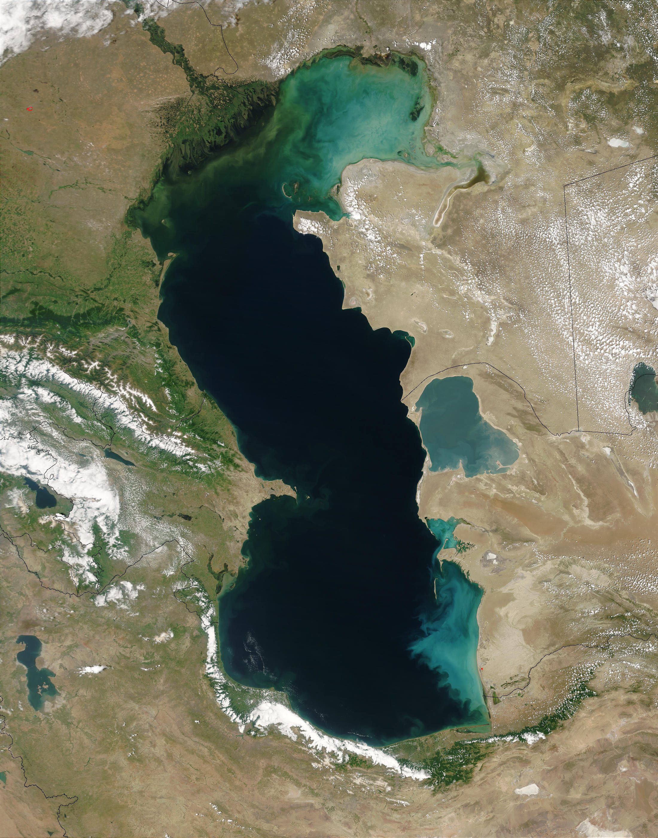
The first time you see pictures of Caspian Sea, your brain kinda struggles to process the scale. Is it a lake? Is it an ocean? Well, technically, it’s the world’s largest inland body of water. It sits there, wedged between Europe and Asia, defying easy labels. If you look at satellite imagery from NASA’s Earth Observatory, the northern part looks like a shallow, murky green puddle, while the southern depths near Iran are a brooding, deep indigo. It’s a massive contradiction.
Most people think of a sea as something with a tide and an outlet. The Caspian has neither. It’s landlocked. Yet, it’s salty. Sorta. The salinity is about one-third that of the ocean, which means if you’re swimming in it, you won't bob quite as easily as you would in the Mediterranean. Honestly, the photos don't always capture the smell—that distinctive mix of salt air and, in some places, the faint metallic tang of the massive oil industry that keeps the regional economies humming.
The Visual Drama of a Disappearing Coastline
If you scroll through recent pictures of Caspian Sea taken near Kazakhstan or the Russian port of Makhachkala, you’ll notice something unsettling. The water is retreating. It’s not just a seasonal thing. Since the mid-1990s, the water level has been dropping by several centimeters every single year. Scientists like Matthias Prange from the University of Bremen have published research suggesting that by the end of the century, the Caspian could be nine to eighteen meters lower than it is today.
That’s a huge deal.
When you look at photos of the Absheron Peninsula in Azerbaijan, you see abandoned piers that used to be underwater. Now, they’re just skeletal wooden structures sticking out of the mud. It creates this eerie, post-apocalyptic aesthetic that photographers love, but it’s a nightmare for local logistics and the environment. The northern basin is so shallow—sometimes only five or six meters deep—that even a small drop in sea level turns kilometers of seabed into dusty wasteland. It’s a visual reminder that "permanent" geography is actually pretty fragile.
Why the Colors Shift So Radically
Ever wonder why some pictures of Caspian Sea show turquoise Caribbean-style water while others look like grey sludge? It’s all about the sediment and the depth. The Volga River, which provides about 80% of the sea's inflow, dumps a massive amount of silt and freshwater into the north. This makes the water turbid. In the summer, you get these incredible phytoplankton blooms. From space, these look like swirling neon green ribbons. It’s beautiful, sure, but it’s also a sign of high nutrient loads that can lead to "dead zones" where oxygen levels plummet.
Down south, off the coast of Iran and Turkmenistan, the floor drops away into a massive abyss. Here, the water reaches depths of over 1,000 meters. The color here is a deep, sapphire blue. If you’re standing on the beach in Ramsar, Iran, looking out, it feels like looking into the open Pacific. The contrast between the rugged, green Alborz Mountains and the dark sea creates some of the most stunning photography in the entire region. It’s totally different from the flat, desert-like vistas of the Kazakh side.
The Weird Case of the Kara-Bogaz-Gol
There is this one specific spot you have to see to believe. It's called the Kara-Bogaz-Gol. It’s a shallow lagoon on the eastern side, in Turkmenistan. It’s separated from the main sea by a thin sandbar, and it is incredibly salty.
- The water is so saturated with salt that it looks like a white, crusty mirror.
- In the 1980s, Soviet engineers actually dammed it off to stop water loss, but the lagoon dried up completely, creating salt storms that ruined local agriculture.
- They eventually reopened the channel, and today, it’s one of the primary sources of sodium sulfate globally.
Photos from this area look like they were taken on another planet. You have these blindingly white salt flats meeting a thin strip of turquoise water under a hot, hazy sky. It’s harsh. It’s beautiful. It’s also a cautionary tale about what happens when humans try to "fix" a sea that’s already complicated enough.
Life Beneath the Surface (And the Camera Lens)
We can't talk about pictures of Caspian Sea without mentioning the sturgeon. This is the home of the Beluga sturgeon, the fish that gives us the world’s most expensive caviar. These fish are prehistoric. They look like armored torpedoes. Unfortunately, you won't see many photos of them in the wild anymore. Overfishing and habitat loss have pushed them to the brink.
Then there’s the Caspian Seal. It’s the only marine mammal in the sea. They’re cute, they’re chubby, and they’re also in trouble. They spend their winters on the ice in the northern part of the sea. If you find a photo of a seal lounging on a chunk of ice with a backdrop of a Kazakh oil rig, you’ve basically captured the modern Caspian in a single frame: a delicate ecosystem struggling to coexist with heavy industry.
Navigating the Geopolitics of a Photo
Taking pictures in this region isn't always as simple as pointing and clicking. Because the Caspian is loaded with oil and gas, many coastal areas are heavily militarized or restricted. In Baku, the "Caspian Waterfront" is a glitzy, modern promenade with the Flame Towers glowing in the background. It’s the face Azerbaijan wants the world to see. But if you head a few miles down the coast to the Neft Daşları (Oil Rocks), things get complicated.
Neft Daşları is a full-blown functional city built on stilts in the middle of the sea. It started in 1949 and has miles of roads and apartment buildings all hovering over the water. It’s a photographer’s dream, but getting permission to document it is famously difficult. It represents the "Black Gold" that has defined the Caspian's modern history. The juxtaposition of rusty 1950s Soviet steel and the shimmering, eternal water is some of the most compelling visual storytelling you can find in the region.
Practical Tips for Capturing the Caspian
If you’re actually planning to go and take your own pictures of Caspian Sea, you need to be smart about your timing and location. The weather here is famously fickle.
- The Best Light: Go to the Iranian coast in the late autumn. The air is crisp, the mountains aren't hidden by haze, and the sunset over the water is legendary.
- The Industrial Aesthetic: Baku is your best bet. The Contrast between the Old City (Icherisheher) and the hyper-modern Caspian shoreline provides endless layers for your shots.
- The Wild Side: Kazakhstan’s Mangystau region. It’s a trek, but the rock formations leading down to the sea look like something out of a sci-fi movie. Think white chalk cliffs and turquoise water.
Don't just stick to the beaches. Some of the most revealing images are found in the port towns like Aktau or Astrakhan. Look for the fishing boats—the small ones, not the industrial trawlers. The people who have lived off this water for generations have a connection to it that a tourist can't see at first glance. Their faces, weathered by the salt and the wind, tell the real story of the sea's decline and resilience.
The Reality of the "Sea" Label
Is it really a sea? Legally, this was a massive debate for decades. If it’s a lake, the resources are split equally. If it’s a sea, they’re split based on the length of the coastline. In 2018, the five littoral states (Russia, Kazakhstan, Turkmenistan, Iran, and Azerbaijan) finally signed a convention giving it a "special legal status." It’s basically both.
This legal ambiguity is why you see such a weird mix of infrastructure in pictures. Huge naval vessels, tiny fishing skiffs, and massive offshore drilling platforms all share the same horizon. It’s a crowded space. And as the water levels continue to drop, the fight for who owns what is only going to get more intense. The photos we take today might be the only record we have of a coastline that won't exist in twenty years.
To truly understand the Caspian, you have to look past the surface-level beauty. Look at the receding tide lines. Look at the rust on the oil rigs. Look at the salt crystals forming on the shore of the Kara-Bogaz-Gol. It’s a place of immense wealth and immense ecological fragility.
Actionable Steps for Exploring the Caspian
If you want to move beyond just looking at pictures and actually experience or document this region, start with these steps:
- Check Visa Requirements Early: Countries like Turkmenistan have some of the strictest visa processes in the world. Azerbaijan, on the other hand, has a very simple e-visa system for many nationalities.
- Monitor Water Levels: Use tools like the Copernicus Marine Service to see real-time data on sea levels and water temperature if you’re planning a trip focused on the northern wetlands.
- Hire Local Guides: Especially in the Kazakh or Iranian sections. The best vantage points for photography are often on private land or require 4x4 vehicles to reach through desert tracks.
- Respect the "No Photo" Zones: Always look for signs near ports or refineries. Security is tight, and "I'm just a tourist" doesn't always work when you're pointing a 600mm lens at a strategic oil terminal.
- Focus on Seasonality: If you want to see the frozen northern Caspian, you need to go in January or February, but be prepared for temperatures that can drop to -20°C. For the lush, green Iranian side, spring is unbeatable.
The Caspian Sea is changing faster than almost any other large body of water on Earth. Whether you're a photographer, a researcher, or just someone fascinated by geography, documenting it now is a race against time. The pictures of Caspian Sea we see in a decade will look vastly different from the ones we see today. That’s not a guess; it’s a geographical certainty.